
")
- Details
- Written by: Super User
- Category: Blog
- Hits: 346
I've finally launched OruxMaps NG as a new app to continue development.

This way, anyone who needs to maintain access to all their files, share data with other apps, and access them easily can keep OruxMaps GP.
This version is now under open test in Google Play:
https://play.google.com/store/apps/details?id=com.orux.oruxmapsNG
The new features added compared to OruxMaps GP are:
https://oruxmaps.com/oruxmaps_ng_news.html
This version can only work in private storage. For those who want to transfer data from OruxMaps GP to OruxMaps NG, you need to copy the following folders:
a) If you granted the app full access to all files, everything will normally be in Internal Storage/oruxmaps/. Copy from /Internal Storage/oruxmaps/ to /Android/media/com.orux.oruxmapsNG/oruxmaps/
b) A more complicated case: if you didn't grant the app full access and everything is in /Android/data/com.orux.oruxmapsDonate/oruxmaps/, you need to take an intermediate step to apply the process in step a). Go to Settings > App Storage > Grant app full access and move everything to /Internal Storage/oruxmaps/. Then you can apply the process in step a).
A tutorial on how to do this step is available:
https://tronpoonpo.blogspot.com/2024/10/almacenamiento-gestion.html
c) If you are a beta user on the forum and haven't granted the app access to all files, you should have everything in /Android/media/com.orux.oruxmapsbeta/oruxmaps/
Copy from /Android/media/com.orux.oruxmapsbeta/oruxmaps/ to /Android/media/com.orux.oruxmapsNG/oruxmaps/
If you are subscribed to the maps (monthly or annually), I can refund your last payment so you can subscribe to OruxMaps NG.
Sorry for the inconvenience...
- Details
- Written by: Super User
- Category: Blog
- Hits: 4798
OruxMaps for iOS
Your Ultimate Companion for Outdoor Activities
Are you an outdoor enthusiast, mountaineer, runner, cyclist,...? OruxMaps is the mobile application you've been waiting for. Specifically developed for professionals and enthusiasts who need a robust, accurate, and easy-to-use GPS navigation tool.
🗺️ Advanced GPS Navigation
Offline and Online Maps
OruxMaps supports multiple map types so you never run out of references:
- Online Maps: Real-time access to satellite, topographic, and terrain maps
- Offline Maps: Complete support for MBTiles and Mapsforge (.map) files. Other map formats (pdf, garmin,... still not available in iOS version, but will arrive in the next future!
- Map Styles:
- Standard
- Satellite (high-resolution imagery)
- Terrain (detailed topographic maps)
- Hybrid (satellite with labels overlay)
Intelligent Navigation System
Our application includes an advanced navigation system that:
- Automatically calculates distance to the next waypoint
- Provides estimated time of arrival (ETA)
- Detects if you've strayed from the planned route
- Optimizes nearby point searches for better performance
📍 Complete Waypoint Management
Create and Customize Waypoints
- Multiple waypoint types: Over 20 different icons to classify your points of interest
- Detailed information: Name, description, coordinates, altitude, and timestamp
- Search and filtering: Quickly find waypoints by name, type, or location
- Flexible sorting: By date, name, type, or location
Advanced Features
- Multiple selection: Manage several waypoints at once
- Map visualization: See all your waypoints directly on the map
- Export: Share waypoints in GPX format
- Complete editing: Modify any aspect of your waypoints
🏃♂️ Activity Recording
Real-Time GPS Tracking
- Continuous recording of your GPS position
- Complete data: Latitude, longitude, altitude, speed, and timestamp
- Multiple segments: Organize your activity into different sections
- Automatic statistics: Distance, time, average speed, elevation gain
Activity Types
OruxMaps + is optimized for multiple activities:
- 🥾 Hiking and mountaineering
- 🚴♂️ Cycling and mountain biking
- 🏃♂️ Running and trail running
- ⛷️ Skiing and winter sports
- 🧗♂️ Climbing and adventure sports
📊 Sports Platform Integration
Strava Connection
- Automatic synchronization: Upload your activities directly to Strava
- Total control: You decide which activities to share
- Compatible formats: GPX export for maximum compatibility
- Complete data: Maintains all GPS, altitude, and time information
SICAMI Integration
- Specialized platform for search and rescue teams
- Live tracking: Share your location in real-time with your team
- Team coordination: See the position of other team members
- Secure communication: Exchange critical information during operations
🔄 Data Import and Export
Universal GPX Format
- Complete import: Reads GPX files with tracks, routes, and waypoints
- Professional export: Generates GPX files compatible with any GPS application
- Complete metadata: Preserves all original information
- OruxMaps support: Full compatibility with specific extensions
File Management
- Smart organization: Automatic folders for tracks and maps
- Quick search: Find any track by name or date
- Backup: Export all your data to keep them safe
🔒 Privacy and Security
Your Information, Under Your Control
- Local storage: All your data is saved on your device
- No proprietary servers: We don't maintain any personal information
- Optional connections: Only connects to Strava or SICAMI when you authorize it
- Secure protocol: All external connections use HTTPS
Total Transparency
- Clear privacy policy: No fine print
- Granular control: You decide exactly what to share and when
- Easy disconnection: You can deauthorize external services at any time
⚡ Optimized Performance
Advanced Technology
- Parallel processing: Uses isolates to keep the UI fluid
- Memory optimization: Efficient handling of large files
- Smart searches: Optimized algorithms for fast navigation
- Advanced caching: Instant response in frequent operations
Smart Battery
- Energy management: Optimized for long activity sessions
- Power saving mode: Reduces consumption when necessary
- Efficient GPS: Automatic configuration according to activity
📱 Intuitive Interface
User-Centered Design
- Material Design: Modern and familiar interface
- Dark mode: Perfect for use in low-light conditions
- Accessibility: Designed to be used with gloves or in adverse conditions
- Responsive: Perfectly adapts to any screen size
User Experience
- Intuitive navigation: Find any function quickly
- Visual feedback: Clear confirmations of all actions
- Contextual help: Tooltips and guides for new users
🌍 Real Use Cases
For Mountaineers and Hikers
- Plan complex routes with multiple waypoints
- Navigate confidently using offline topographic maps
- Record your progress and share experiences on Strava
- Keep track of shelters, water sources, and points of interest
For Athletes
- Train with precise GPS and altitude data
- Analyze your performance with detailed statistics
- Compete with friends by uploading activities to Strava
- Discover new routes and challenges
🔮 The Future of GPS Navigation
OruxMaps + is constantly evolving. Developed to guarantee native performance on all platforms, the application receives regular updates with new features and improvements.
Upcoming Features
- Integration with more sports platforms
- Advanced route analysis
- Augmented reality functions
- Weather prediction improvements
📲 Download OruxMaps
Ready to take your adventures to the next level? OruxMaps + combines the power of a professional GPS with the simplicity of a modern app.
Key Features:
- ✅ Advanced GPS navigation with offline maps
- ✅ Complete waypoint and route management
- ✅ Detailed activity recording
- ✅ Strava and SICAMI integration
- ✅ Total data privacy
- ✅ Intuitive and modern interface
- ✅ Optimized for professionals and enthusiasts
Compatibility
- 📱 iOS and Android
- 🗺️ All standard map formats
- 📊 Compatible with major sports platforms
- 🔄 Synchronization with professional services
Have questions about OruxMaps? Contact us and discover how this application can transform your outdoor activity experience.
OruxMaps: Where professional precision meets ease of use.
- Details
- Written by: Super User
- Category: Blog
- Hits: 3128
Possible error in last versions (10.6.x)

In some cases it seems that Android removes the app permission to access the files, with the latest updates.
If the app cannot access Tracks or maps, check that the following permission is granted for OruxMaps:
Android Settings > Applications > Special permissions > Access to all files
This is the permission that allows the app to access folders when they are at the root of the internal storage.
_________________________________________________________________________________________
- Details
- Written by: Super User
- Category: Blog
- Hits: 2042
New route planner
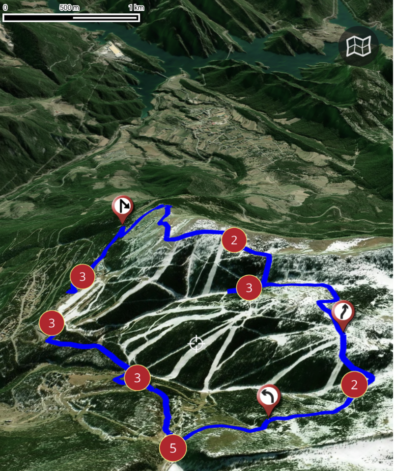
In this video you can see how the new route planner works, combined with the 3D map viewer (subscription required).
- Details
- Written by: Super User
- Category: Blog
- Hits: 4198
Integration with SICAMI
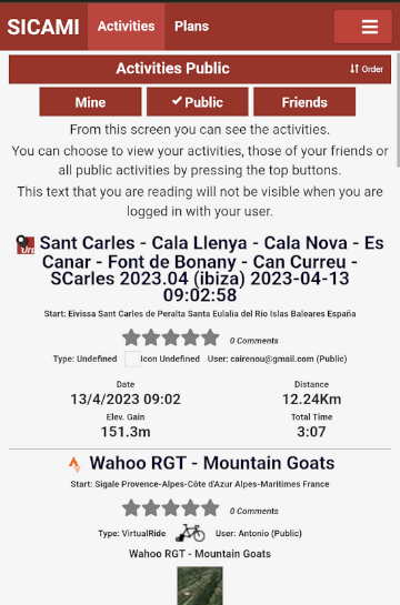
Now OruxMaps is integrated with SICAMI!
When you register your user in OruxMaps (from version 10.0), you have the option of doing it with SICAMI as well. In this way you will enjoy the advantages that its web application offers you.
What is SICAMI?
SICAMI TRACKS allows you to record and analyze your sports activities, such as running, walking, swimming, etc. Also, you can see a map of your routes and get detailed statistics of your progress and performance.
With our app, you can keep a complete record of your sports activities and see how you have improved over time.
Also, you can compare your stats with those of your friends and followers to motivate you to keep progressing.
Also, you can import your activities from other platforms, such as Strava or Garmin, to have all your sports information in one place.
You will have at your disposal accumulated statistics of the activities you carry out and an intuitive and easy-to-use online route viewer and editor.
Sicami is free.
Don't have an account? Sign up
What else does Sicami offer you? we will explain it to you below:
Your routes with another perspective…
View your routes with simulated aerial perspective with the flyover 3D mode
WATCH AN EXAMPLE VIDEO ON YOUTUBE
Your plans…
Plan your route by analyzing the route in detail to discover the most difficult sections, due to their slope or altitude, and those where you can regain strength. More information on this link Plans
To organize a route for cycling, hiking, running, etc., prior planning at home is recommended to avoid problems or setbacks. More information in Guide for a safe route
Your privacy is important
You can choose the level of privacy of your activities and routes. More Information in User Guide
We protect your privacy. For the routes that you make public, when they are seen by people other than you or one of your friends, neither the first nor the last meters will be shown, so that nobody can find out your address.
Connection with other platforms
Strava , you can import activities that you already have in strava to be able to analyze them from Sicami Tracks.
Oruxmaps , we are integrating the many options that Oruxmaps offers with our website. You can upload your tracks from Oruxmaps to Sicami and you can also download from Oruxmaps tracks that are in Sicami.
Statistics
With SICAMI you will have details of the activities that you have planned to carry out or those that you have already carried out.
You will also have statistics of your activities, you can select the period for which you want to see the information. You can go to the statistics section by clicking on this link Statistics
Visit the website! SICAMI
- Details
- Written by: Super User
- Category: Blog
- Hits: 6172
Configuring online maps
The maps that appear in the list of online maps are configured in the onlinemapsources.xml file found in the oruxmaps/mapfiles/ folder.
In that folder are the maps officially offered by OruxMaps. It is a short list of maps, which you can expand with other online maps, from hundreds of existing map sources around the world.
To add your own online maps, the best thing to do is, instead of editing that oruxmaps/mapfiles/onlinemapsources.xml file that can be modified by the app in updates, add your onlinemapsources.xml file in the oruxmaps/mapfiles/customonlinemaps/ folder.
This last folder is not modified by the app, so your personalized online maps are safe.
Where do I get additional maps? Fortunately, there are OruxMaps followers who usually do this type of map compilation, including terrain maps, heat maps, aerial photos,...
If you go to this telegram group you will see some examples:
group: https://t.me/OruxMapsGPS
thread with maps: https://t.me/OruxMapsGPS/46345
Another way, Google: "oruxmaps onlinemapsources.xml" and you will reach multiple distributions of that file, for example:
online maps: https://anygis.ru/Web/Html/Orux_en
orux
- Details
- Written by: Super User
- Category: Blog
- Hits: 3119
3D Mapbox Maps
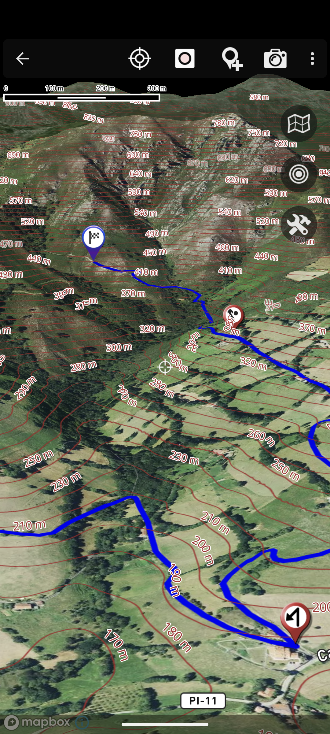
In the latest versions, for users who have subscribed to the featured maps, there is now the option of using the fantastic 3D viewer with which you can enjoy extraordinary views of the map and the routes you are following.
I leave you a link to the video where the possibilities of this viewer are shown: 3D Mapbox Viewer
Remember, in order to use these featured maps, you need to subscribe, for a small monthly/annual fee. From the list of maps there is a button to access the subscriptions.
Go ahead and subscribe!
- Details
- Written by: Super User
- Category: Blog
- Hits: 2676
OruxSoS
OruxSoS application aims to be a tool that helps people who carry out outdoor activities alone so that, in the event of an accident, the app can send an alert message to the phones that the user determines.
In order to work, when you activate the alarm, it accesses the GPS positioning data, even when you leave the app in the background, in order to determine if there is displacement.
If these conditions occur, the app starts a 30-second countdown, which allows you to cancel the sending of the SMS. If it is not cancelled, the SMS are sent to the indicated telephone numbers.
It is NOT useful if:
—>There is NO displacement, since it uses the GPS to determine if there is movement or not.
—>There is NO mobile coverage. The application launches the alert messages by means of an SMS through the mobile network. So if there is no coverage, it won\'t work.
Take all these conditions into account. Remember that the app may not work for various reasons, so, in addition to its use, it is recommended to use other complementary security means and explain or indicate to other people the route you intend to take before starting your activity.
OruxSoS in Google Play: OruxSoS
- Details
- Written by: Super User
- Category: Blog
- Hits: 5848
Android +11 Scoped Storage
First of all, the interface, for users who were already using previous versions. By default the new 'unified interface' is used. Going back to the old one is easy: Global Settings-->'Unified Interface' (remove selection).
The complex part, the new storage system:
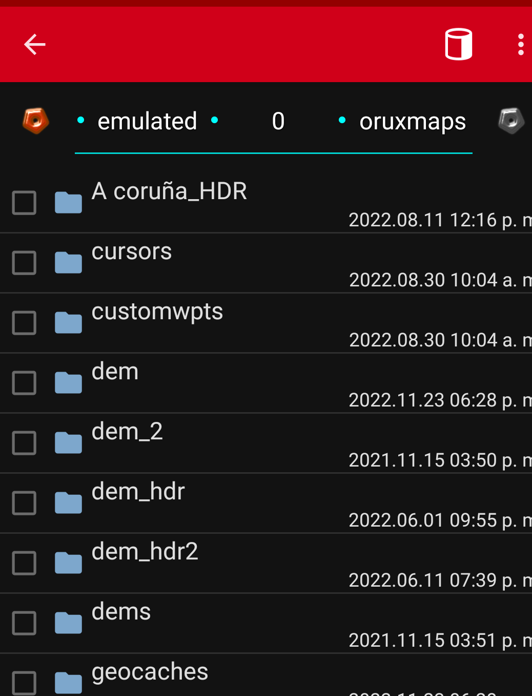
Version 9.x uses the Android SDK level that forces apps to use the private storage of each app, restricting the options to access the root of internal storage and SD.
This prevents keeping the maps/tracks,... where the app has always had them.
One of the important consequences of this change is that if private folders are being used, and the app is uninstalled, ALL data is deleted, so it is important to keep a copy of important data.
Not everything is lost! The Android file browser (Files) does not make it easy to access and copy operations in the app's folders. But there are browsers, such as Explorer: Explorer that can access the app folders, in the path:
Android/data/
com.orux.oruxmapsDonate/files/oruxmaps/
In that path are all the data of the app, you can access them and copy/move data there.
Another file browser that can access private app folders: Xplore
And if you are using Android 13, you can use this: xda-developers
Another option, it is a trick
1.-Unisntall the GP version.
2.-Install and open (IMPORTANT!, IF THIS SMALL APP ASKS YOU FOR PERMISSION TO ACCESS FILES, YOU MUST SAY YES) this small apk:OruxMapsGP0.0.2.apk It is an empty apk, it allows you, when updating to the real GP version, to keep permissions about access to the internal storage, like the old versions.
3.-Finally upgrade to the GP version from Google Play. IF THE APP ASKS YOU TO MIGRATE TO ANDROID 11 STORAGE SAY 'MAYBE LATER'.
After the upgrade, the app should be able to access all the folders, including the old from root SD or the root internal storage.
Remember do not migrate to Android 11!
And if you have to uninstall the app, you have to do the same procedure if you want the app to access the old folders.